
This entry was original published as a Ride Report on the Adventure Rider (ADVrider) forums. The only changes are reformatting to flow as a single article.
- Prologue
- Day 1: Down the Green Mountains
- Day 2: Across New England
- Day 3: Acadian Entry
- Day 4: Fundy Crossing
- Day 5: On the South Shore
- Day 6: Halifax
- Day 7: The Eastern Shore
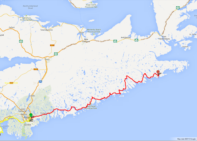
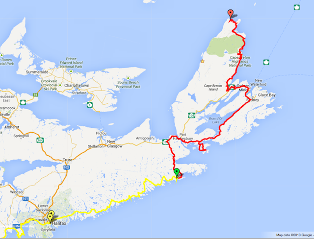
- Day 8: Across Cape Breton
- Day 9: Meat Cove
- Day 10: Cabot Trail – West
- Day 11: PEI to Fredericton
- Day 12: Northern Maine
- Day 13: Green Mountain Return
- Summary Statistics
Prologue
I’m continually thankful that I get to live in one of the more scenic corners of the planet. Central Vermont boasts numerous twisty roads that tie together charming villages over rolling farmland and steep mountainsides. While my back-yard riding options are nothing to take for granted, it was traveling by motorcycle that attracted me to riding in the first place. I have the travel-bug and long to explore exotic places. Reading the fabulous trip reports at ADVrider has only fueled a greater hunger to step out of my day-to-day environment and explore new places. Since the Rocky Mountains are too far to fit into my vacation schedule this summer, I settled on maritime Canada (and Nova Scotia in particular) as a suitable destination from my two-week end-of-summer trip. As an inlander, the sea-coast provides a novel and ever changing landscape to feast my eyes upon and the population density seems about right to allow me to get a bit of wilderness fix while never being too far from the next town. I also wanted to try my hand at locating camping spots on deserted beaches and former logging cuts as a way to get away from the RV crowd at public campgrounds. While I wasn’t quite sure what to expect on the ground, zooming around in Google Earth seemed to indicate many likely-suitable spots in Canada and Maine where no one would notice or mind a tent for the night.
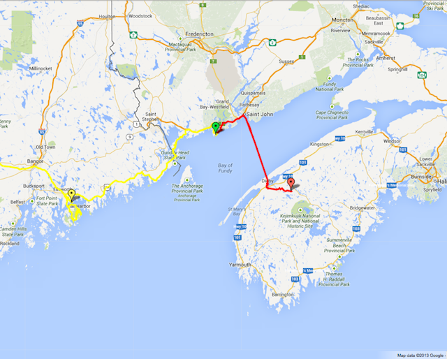
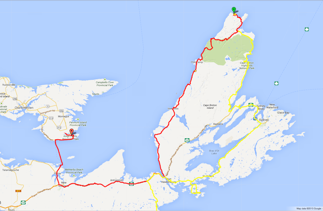
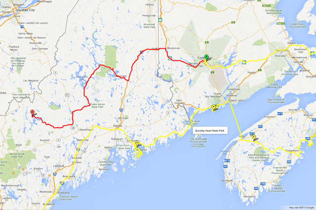
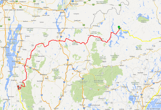
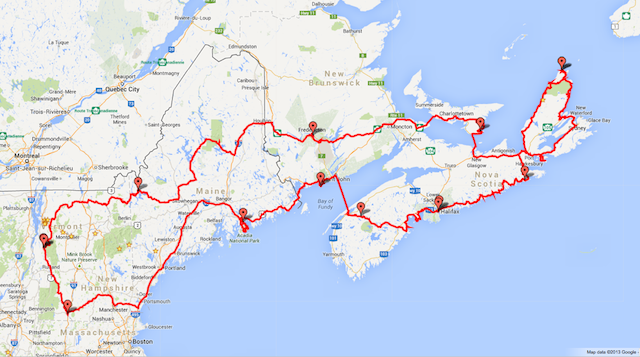
My best guess at a planned route:

(The actual route can be seen below at the end of this post)
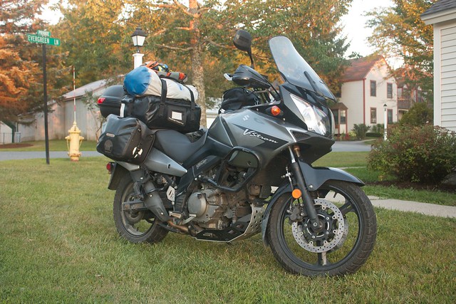
While the vacation itself is certainly the goal, at least 25% of the fun is thinking about and preparing for the adventure. In the weeks leading-up to the trip I took care of various maintenance on the bike, changing the oil and tires as well as adding a top-case and a few other bits and bobs. This trip also gave me an excuse to refresh my camp stove and a few other pieces of gear I haven’t needed in a while. One of the things I thought I’d try out was this brand new super-hydrophobic-and-oleophobic coating called “NeverWet”. After watching their YouTube videos I thought, “this would be perfect to keep water/mud off my boots/riding-pants”. I’ll come back to this later, but the moral of the story: don’t. Preparations began in earnest a week out and by the night before I had the house clean, the bike packed, and was ready to go.
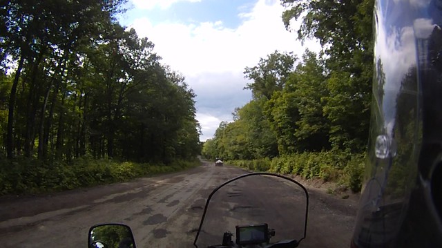
Day 1: Down the Green Mountains
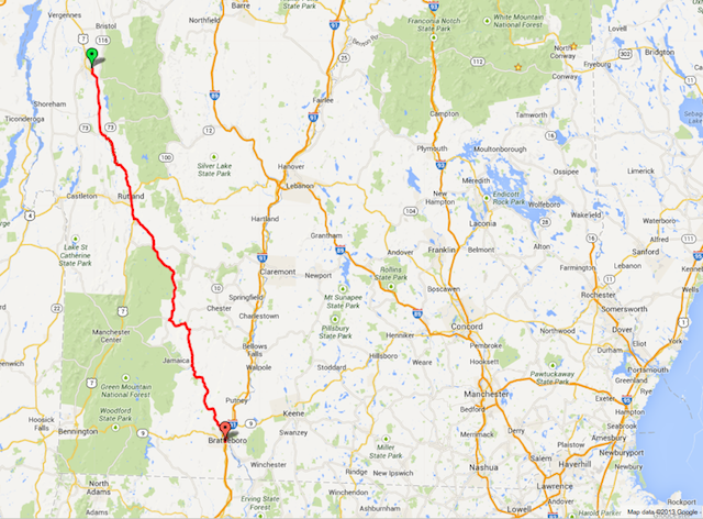
99 miles, 1:58 moving, rural highways and mountain roads.
Saturday I woke up at dawn (a rarity for me), took a shower, and headed out the door. My trip would begin with a day and a half Aikido seminar in Brattleboro, two hours south in the bottom corner of Vermont. For those not familiar with Aikido, it is a martial art that focuses on blending with and redirecting the energy of an attacker. This seminar was focused on the receiving end of the engagement — specifically, how to release the tension in your body and softly “give up” on the position of extremities (your arm for instance) so as to retain a balanced, strong core that can continue the attack/connection. I hope I’ll be able to translate these lessons to riding as I see many parallels — staying grounded through the torso and legs while the arms stay soft really helps with control when the bike hits an unexpected surface. A lovely community of practitioners attended this event and the river-swimming, potluck, and story-telling were *almost* as much fun as the training. 😉
Day 2: Across New England
344 miles, 5:32 moving, almost all super-slab.
I’d never been much east of Portland, Maine, so after a morning of training and a quick lunch I loaded up and cranked out the super-slab miles to Ellsworth, Maine and the Lamoine State Park campground, across the bay from Mount Desert Island. While the weather was perfect and the traffic light, this was [hopefully] the most boring day of the trip. Thank goodness for the Sena Bluetooth headset and many hours of podcasts to keep me sane.
I pulled into the campground just after dark. The park office had just closed, so I found my pre-reserved site, set up my tent and proceeded to make my Mountain House “lasagna with meat sauce” freeze-dried dinner with mixed success. I recognize that these are “just add hot water and stir”, but I was tired and hungry and figured I’d follow the suggested directions on the ziplock-topped bag that indicated that the water and solids be combined in the bag. Unfortunately, my spoon was much too short to reach far into the bag, so I closed the ziplock top and tried shaking… …only to have the ziplock open on the third shake, releasing a geyser of scalding sauce. After waiting for it to cool I poured the contents into my bowl only to find that my shaking had not produced sufficient turbulence and there were still numerous dry, powdery clumps floating on a lake of too-thin sauce. Not appetizing. While my bowl was too full to get vigorous I was eventually able to wet the clumps and at least homogenize the mixture a bit if not totally reconstitute it. In my ravenous state the result was at least edible if quite distant from “succulent”.
After my much needed and refreshing shower I headed to bed. About 15 minutes later I awoke from my slumber to the wailing of a toddler in the next site over — who continued to wail for about 30 minutes until the dad finally gave up, loaded his child up, and drove him/her off somewhere else settle down. I hope the kid wasn’t deathly ill or something, but damn did he/she have some lungs.
Day 3: Acadian Entry
225 miles, (forgot to check the moving-time on the GPS), coastal highways and back-roads.
Monday morning dawned with a grey cast and a light rain. Screaming children aside, I had slept pretty well and woke up at 7am. The first sound I heard after pulling out the ear-plugs was dripping on the tent-fly, so after checking the weather radar I went back to sleep for another hour to wait out the drizzle. I rolled out of bed at 9am, took some photos by the water, had a more-successful-than-dinner-was breakfast, and finally rolled out of the campground at 10am — a bit later than I was hoping.
Given the remnants of dreary weather I just did a quick loop around Acadia National Park rather than stopping to hike or explore. My main target in the park was to drive up Cadillac Mountain. It’s road was beautiful and twisty, and if not for the heavy traffic and 25mph speed limit the road would be a destination in itself. With the traffic and speed limit it was still quite fun (and the vistas were great), but I wouldn’t recommend traveling too far just to ride it. I stopped for a quick look around — low clouds made recreating the classic Frenchman Bay photos impossible — then headed down to Bar Harbor for lunch. At this point it was 1pm and I was about two hours behind the schedule so I stopped at the first tourist-trap lobster place I could find for my obligatory lobster-roll and lobster bisque. The fare was tasty but pretty basic for the exorbitant price, so I left as quickly as possible to get back on the road.
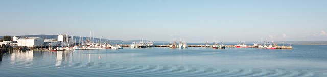
From Bar Harbor I took the coastal route (US-1, US-1A, and ME-191) to it’s end in Lubec and the bridge to the Canadian Campobello Island. The coastal route east of Ellsworth was lovely and kept getting better as I split off onto the smaller US-1A and then the even smaller ME-191. The inland sections were often just pine trees, but the views of bays and inlets were lovely. ME-191 was especially fun. Along it’s rolling curves I came across the tiny village of Cutler. At 5pm the late afternoon sun bathed the harbor in a lovely light while the boats unloaded their catch in the harbor. The clearing weather may have had something to do with it, but it was my favorite view of the Maine coast.
As I rode along I kept pondering the name “Acadia” as it has something of a magical or mystical ring to it. Finally I broke down and looked it up. “[It] derives from the Arcadia district in Greece which since classical antiquity has the extended meanings of “refuge” or “idyllic place”. (– Wikipedia). Quite a fitting name for this beautiful rugged coastline with snug harbors.
After crossing the bridge into Canada’s Campobello Island I stopped at the border check-point and found that I was now yet another hour behind schedule due to my entry into the Atlantic time-zone and the last ferry to Deer Island would be leaving soon. With no time to explore Campobello Island I head straight for the “ferry terminal”, a gravel road to a gravel beach with a small concrete boat-launch. Shortly the ferry pulled up and dropped it’s ramp onto the boat launch and all three waiting vehicles drove aboard. This tiny ferry was a neat design; rather than a pilot-house in the center, the pilot house was a separate vessel permanently hitched to the side of the barge-portion by means of an articulated metal frame. As the ferry backed away from the shore it swung away from the barge and then nestled back in facing the other direction — quite a trick!

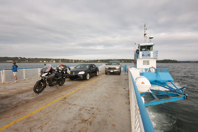
The ride to Deer Island was quite scenic, passing numerous small islands on both the US and Canadian sides of the border. Upon reaching Deer Island there was no concrete ramp; instead the ferry just dropped the ramp on the wet sand and we drove up the beach. Deer Island was also quite scenic with a nice twisty road hugging the coast all the way to the second (year-round) ferry to mainland New Brunswick.

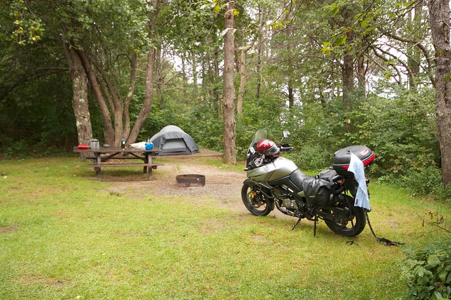
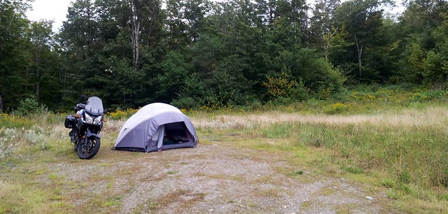
Monday night was my first chance to try my hand at camping in hidden-away spots and I had found a few likely candidates on the coast near Dipper Harbor, where dirt roads led to the sea with no houses nearby. As I rode down the first lane the road got narrower and narrower over several kilometers until it eventually turned to an ATV track near a small pond. It was getting dark so I only explored down the ATV trail a short way before realizing that it was going to turn to mud before I found a stopping place better than the pond. The pond wasn’t quite as ideal as I had hoped since the mosquitos were ferocious and I couldn’t see the ocean, but hey, at least it was a free camping spot that was unlikely to disturb or be disturbed. With liberal sprays of Off to my person I proceeded to pitch my tent and get dinner going in the fading light. This time I skipped on the “prepare in bag” suggestion and made my Mountain House beef stroganoff right in my bowl. I over-filled the water a little, but at least I was able to stir properly. 
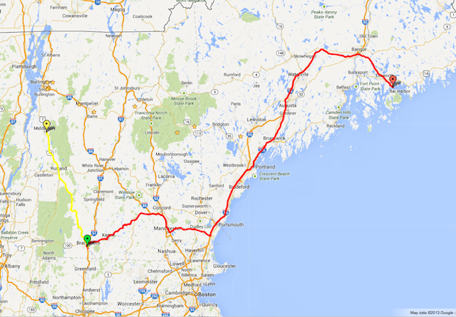
Day 4: Fundy Crossing
69 miles of riding/44 miles of ferry
I awoke in my Dipper Harbor campsite to a glorious blue-sky day with golden light falling on the pond. After rebooting my phone for the third time it finally was able to register on the Bell Canada network with the prepaid SIM card I had ordered ahead of the trip from Similicious. Yay for 4G in the woods! Pulling up Google Earth and browsing my location I noticed another reason for the minimal residential development along on this road: my campsite was a mile from the Point Lepreau Nuclear Generating Station. I don’t think I’ll make a practice of camping next to power plants, but it did help to keep the traffic low. 🙂
The mosquitos were still swarming in the morning, so I ate my oatmeal in the tent and packed up as quickly as possible. On my way out the lane to the main road I noted several nice spots with ocean views that I had missed on my way in. Out-of-the-way-camping lesson #1: Look for spots at least an hour before sunset so that you have a chance to look at a couple and then go back to the best one.
In recent life I’ve proven myself to be a reasonably organized person who can make it to meetings and appointments on time, but I’m something of a night-owl and getting up and going in the morning has never been a strong suit of mine. I haven’t gotten a good rhythm with it yet and breaking camp, packing up, and getting on the road took me a full two hours, eating up most of the morning. From Dipper Harbor I jumped on the expressway to Saint John in order to catch the noon ferry across the Bay of Fundy to Digby, Nova Scotia. My Lonely Planet guidebook has raved about how quaint the old downtown of Saint John is, but approaching the city from the west the skyline of industrial smoke-stacks quenched any regrets about heading straight for the ferry terminal.
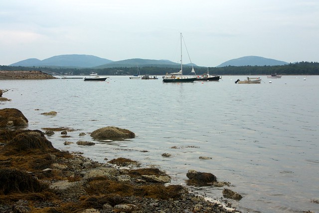
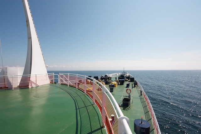
After boarding and strapping down the bike, I spent most of the 3-hour crossing enjoying a lunch of bacon-wrapped scallops and uploading photos via the free wifi. Most of the bay was fogged in so there wasn’t too much to see until we got close to the shore.
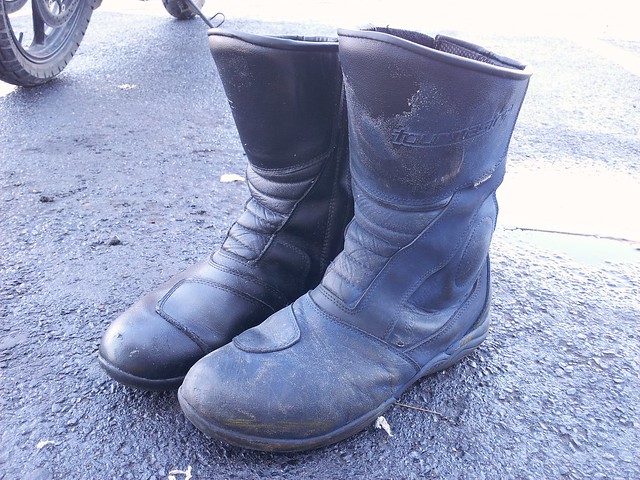
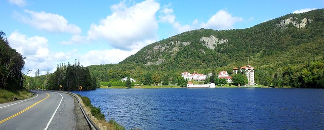
As much as I wanted to get on the road, I wanted to give the Annapolis Valley and Fundy shore of Nova Scotia at least a bit of a gander since I wasn’t likely to be on this side of the peninsula again. First though, I wanted to deal with the NeverWet coating I mentioned in my first post. While the coating does seem to live up to its super-hydrophobic-and-oleophobic claims (meaning that both water and oil run right off without wetting the surface), what it doesn’t do (and honestly doesn’t claim to do) is have *any* durability. When I first applied the coating I noticed that it gave my black riding boots a “bad sky-blue spray paint job” look to them, but I was willing to disregard the appearance in order to test the efficacy of the product. Unfortunately, it turns out that the coating rubs off with the slightest abrasion or flexing of the material, loosing all benefit while leaving the boots looking even worse. In Digby I decided that enough was enough and I was going to get the NeverWet off so I could replace it with a proper boot-waterproofing. I stopped by the town’s hardware store to pick up some paint thinner and the poor durability of the NeverWet came in handy as I spent about 45 minutes scrubbing all traces of it off my gear.
That task complete, I headed back downtown to walk around the harbor and have a lovely scallop dinner at the Fundy Restaurant overlooking the harbor. I’ve eaten a lot of scallops over the years, but these were the best I’ve ever had.
The Wharf Rat Rally was starting up in Digby the next day and since the loud pipes and custom paint-jobs thing isn’t really my scene I pulled out of the rapidly-filling town and headed inland. The Lonely Planet made the little village of Bear River sound like a nice place to visit, so I routed myself via this hamlet. I’m beginning to doubt the notability of mention in the guide since the Bear River I saw was a tiny village with 3 buildings on the river and a couple of residential streets — certainly a pleasant-looking place, but not a destination unless you are really hard-up for sights.
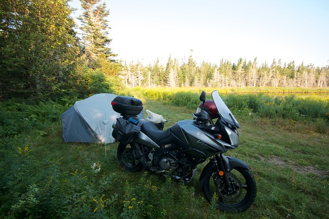
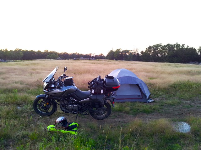
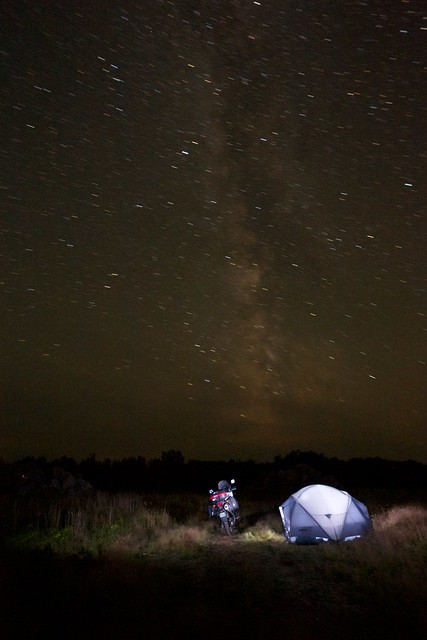
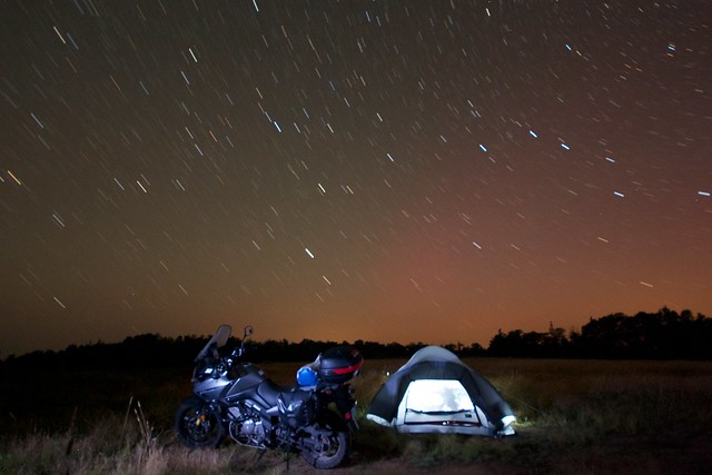
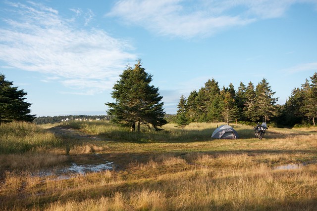
From Bear River I was aiming at a campsite about 30 minutes away along a Mersey River near Maitland Bridge. The dirt road I was traveling hadn’t been graded in a while though, forcing me to keep the speed down so as to not slam into the frequent potholes and washboard bumps. 30 minutes later I was only half-way along and the sun was heading down to the horizon just as I passed a beautiful hill-top meadow in the middle of nowhere. The meadow was a patchwork of knee-high golden wild grasses mixed in with other darker green clumps of weeds and other vegetation. Somewhat recent heavy-equipment tracks crisscrossed the meadow and I didn’t see any no-trespassing signs or a gate so I wound my way along the track up to the top of the hill where I found a nice flat spot between two 30-foot-tall piles of round boulders. The meadow had obviously been cleared of both trees and rocks for some purpose, but I couldn’t figure out what. It was a truly glorious spot and I didn’t seem in danger of disturbing anyone, so I made camp in the grass and settled in for a beautiful, silent, and starry night.
Day 5: On the South Shore

177 miles, 4:15 moving
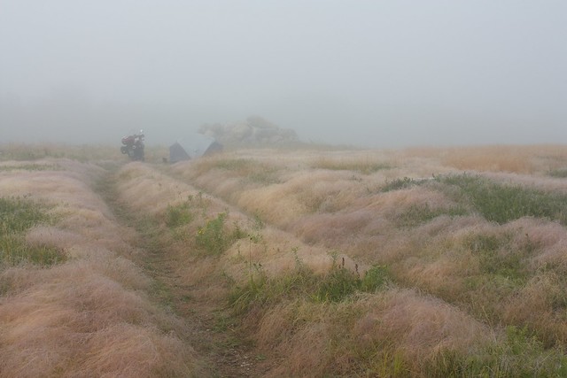
After a deep and restful sleep in the hill-top meadow I awoke to the soft light of a misty morning. A heavy dew covered everything and the mists muted some sounds and carried others in the funny way it does. I had an apple and granola bar for breakfast, packed up the tent, and wound my way back out of the meadow.

About 1/2 a mile down the road at the next meadow I had my answer to the existence of these lovely clearings with large piles of rocks: “Commercial wild blueberries — no trespassing”. Come to think of it, I had noticed some 1-foot high scrubby shrubbery scattered about in patches in the meadow that I thankfully didn’t trample. I guess the meadow was just too good to be true; wild blueberries are now another item to add to the list of crops to avoid damaging. About a half hour later I hit pavement again and came upon my original camping target which turned out to be a lovely river-access point with plenty of space for camping. The meadow was certainly more scenic, but given the need for accidental trespassing in the meadow, the river spot would be a better choice for future trips.
After a brief pause for coffee at the Hollow Log Cafe near Kejimkujik National Park I continued my way across the peninsula to the charming town of Lunenburg. I had a lunch of scallop chowder and fish cakes at the Magnolia Grill, visited the Fisheries Museum, and wandered the town for several hours.
Lunenburg was impressive in that it managed to be a lovely and historic tourist destination while still retaining a charming “real town” feel. As I continued up the coast toward Halifax many of the towns began to feel like beach-cottage municipalities with no real town center that I could find.
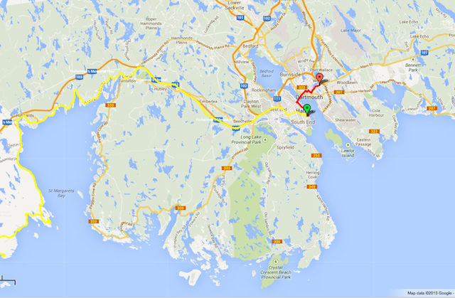
After several hours in Lunenburg I felt like I’d sufficiently seen the place and head off down the coast-road exploring to the end of several peninsulas. The coastal road was a blast to ride and the rocky sea-shore a lovely compliment to the mostly-smooth pavement. By the time I reached the Head of Saint Margaret’s Bay it was getting on about 5:30pm and I was ready to wind down and get off the road. I’d hoped to head down the next peninsula to Peggy’s cove this evening but a heavy fog rolling in from the sea made attempting to push beyond my flagging energy reserves completely pointless. As I was on the outskirts of Halifax I figured I’d continue into the city for the night as there seemed to be no lodging anywhere near me. I got a last-minute room at the “Hosteling International — Halifax”, ate some Thai food, then spent a long evening doing laundry and drinking beer with a guy named John from NYC who is spending 11 weeks in 11 hostels around Canada and northern Europe as a retirement kick-off trip.
Day 6: Halifax
2-3 miles walking, 5 miles riding
After an all-too-brief sleep I was startled awake by my alarm clock that I hadn’t meant to set. I began kicking myself only to remember that I was in a [expensive] metered parking space and needed to find a garage in which to stash the bike for the day. Several laps around the neighborhood later I’d located the municipal garage and wandered back to the hostel just a bit too awake to bother going back to sleep.
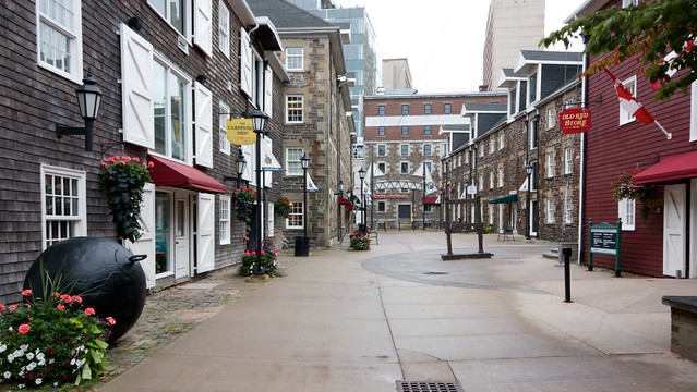
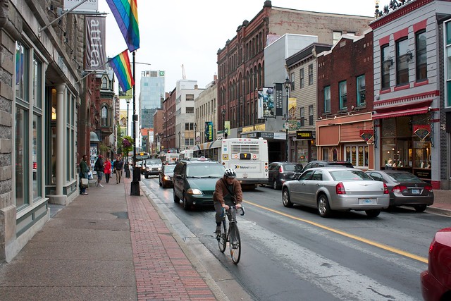
With skies heavy and a light drizzle all day I spent the morning in the hostel processing photos and writing these entries. Since I had already seen Lunenburg’s maritime museum I skipped Halifax’s version and walked around the waterfront looking for restaurants. After a late lunch of seafood pot-pie I continued wandering the streets. Drizzle aside, Halifax seems like a really great city. The architecture is an eclectic mix of historic and modern where the historic is quite lovely stone and brick-work while the modern has an unfortunate blocky heft to it. I won’t call the modern buildings ugly, but most certainly aren’t inspirational in their design. While the city is large enough to have many things going on, it’s not overwhelmingly vast and the downtown is totally manageable on foot.
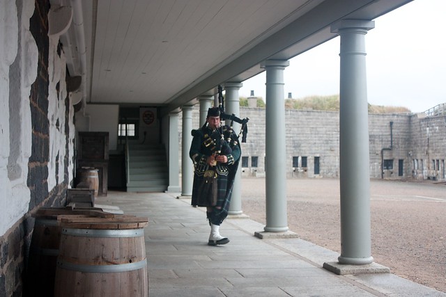
After roaming the streets for a while I headed up the hill to the citadel — a Victorian-era fortress that was the central fortification of several used by the British to maintain control the Halifax harbor throughout the 18th and 19th centuries. The citadel is now run as a historic site by Parks Canada with interpretive guides dress in period garb from the 1870 garrison of the 78th Highlander Brigade. While touring the grounds I chatted a bit with the staff bagpiper, a young fellow who also plays with an international competition band when not dressed period garb at the citadel. I haven’t played the pipes in years but my favorite music has always been the wispy melodies of the ancient piobaireachd style rather than the up-beat marches so often played by the pipe bands I see in parades. After mentioning this to the piper he kindly launched in to a lovely 10-minute piobaireachd that chased away the melancholy brought on by the minimal sleep and grey weather.
Since I only had a single night booked at the hostel I found a Quality Inn across the harbor in Dartmouth to stay for the rest of the rainy night and dry out my still-damp tent. While it was only 4 miles across the city I managed to have to close-calls enroute. After crossing the harbor I approached the toll-plaza and headed for the staffed lane since I didn’t want to be digging around for coins and holding up traffic. I pulled in, put the bike in neutral, took of the gloves, got out my wallet, handed the guy a $20, got my change, put it back in my wallet, put the wallet away, put on the gloves, shifted into first, and then pull away. As I pulled out toward the crossbar-gate a loud buzzer blared and lights flashed saying “STOP AND PAY TOLL” causing me to almost loose it before the gate popped up and I regained my balance. Later when I reached the hotel it turns out that I had been given full change for the $20 and was expected to pull forward and put $1 coin into the machine before proceeding — not something that was obvious to me at the time. Just as my heart-rate was going back down I rounded a very slight bend and felt the front end drop as the front tire skated away on a white-painted arrow in the lane. Luckily the tire hooked up a few feet later on the pavement and I was left with only some crazy wobbles and a return to the elevated heart-rate. I eased it the last mile to the Quality Inn and was happy to be off the wet road.
Once in my room I pulled out the 50 feet of para-cord that I had bought on a whim while browsing the camping section at Dick’s a few weeks ago and proceeded to turn my room into a crazy nest of drying gear. Hopefully staying in the motel will allow me to get on the road early and make some good miles.
Day 7: The Eastern Shore
169 miles, 3:30 moving
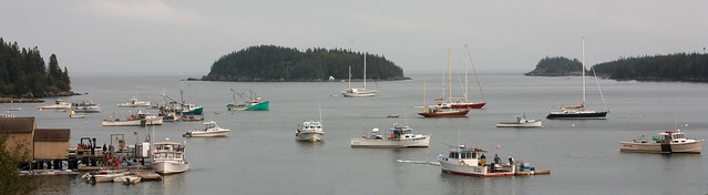
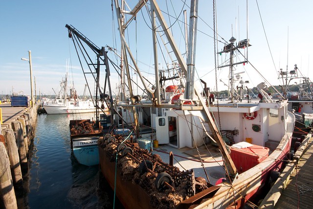
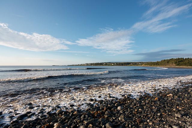
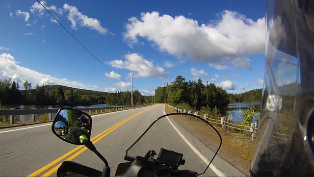
While my alarm going off told me it was time to get up, a headache and general queasiness convinced me otherwise. Back to sleep for another few hours; this isn’t going to be an early morning after all. The continental breakfast at the Dartmouth Quality Inn and a walk to the grocery store for some ibuprofen improved my state enough to get on the road by 11:45. My destination for the day was Canso, a little village on the far-eastern tip of the the Nova Scotia peninsula. The rains had passed, pushed on their way by an impressive wind, gusts of which several times threatened to peel my off the bike. After about half an hour of buffeting on the hill-top highway the road narrowed and tucked in along the shoreline, protected a bit from the landward winds. I stopped for a tasty bowl of chowder and a salad in Sheet Harbour and continued on down the beautiful coastline with grey skies overhead.
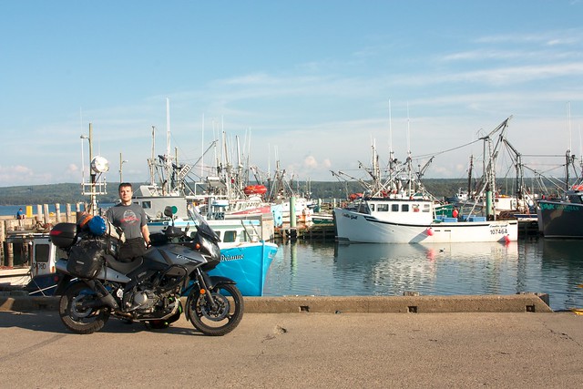
While crossing a bay on the County Harbour cable-ferry I had a nice chat with a young woman (who grew up in Canso) and her French boyfriend who had recently been traveling around New Zealand in a similar fashion, camping on beaches wherever looked nice. She mentioned that Canso is a pretty little village, but that the closest restaurant was probably 30 minutes away in Guysborough. As if to highlight how small a place it is, upon hearing that she was from Canso the ferryman (who had moved away from Canso some years back) and woman started swapping lists of names to determine how many friends and family they had in common.
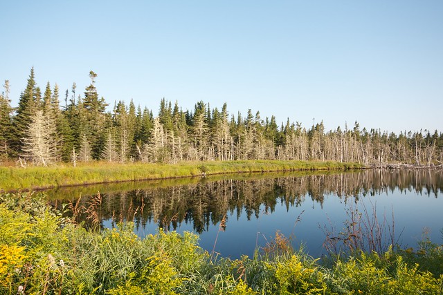
The Route 316 east of the County Harbour ferry had a pretty terrible surface, massively frost-heaved with grass growing in many of the larger cracks in the road. This section must be painful in cars as any attempt to save the right tire from a frost heave would simply sacrifice the left to another. On the bike though I was partially able to weave about and avoid the worst of the jolts. At about 4:30 pulled over for some photos along the scenic New Harbour River.
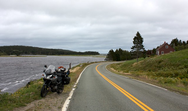
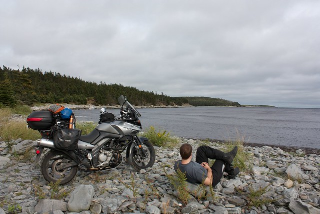
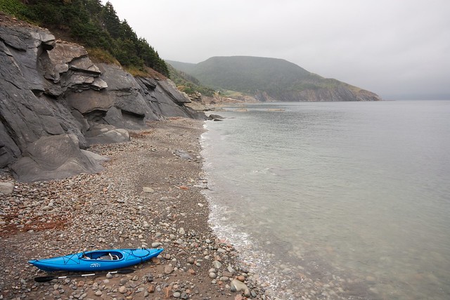
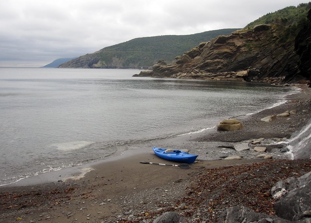
One of the potential camping spots I’d identified via satellite imagery was just around the bend at the mouth of the river so I pulled in to see how the ground-truth matched with the overhead view. The grassy area visible in satellite view had partially flooded with the recent rains, but the water wasn’t too deep and I was able to splash through to some small sand dunes separating the grass from the rocky beach. As I relaxed a bit and took some photos the sun began peeking through the clouds and began to regret needing to leave this spot and continue on my way for another few hours. It took me a bit before I caught myself and remembered that I really didn’t have anywhere that I needed to be. With the exception of eventually getting home by a certain date, all of my planning was really just to help me have a good time. Sure I had only done a short day of riding and still had several before sunset, but why not relax here and watch the waves?
Mind made up, I verified that there were no “No Camping” signs even though there were several fire rings in the grass and on the dunes. I set up my tent in the short grass behind the dunes and carried my cookware over to the beach to make dinner next to the water. As I was supping an older couple backed their car out to the beach and looked around for a few moment a bit awkwardly but didn’t seem as if they were going to stay. I had a feeling I’d been spotted and they were making sure everything was on the up-and-up. I said hello and asked if they lived nearby. “Just across the way” they said, pointing to the houses on the other side of the cove. “Would I be bothering anyone by camping here for the night?” I asked. “Not at all, people do it all the time,” was the reply. I guess I passed muster as that was the end of the conversation and they promptly got in their car and left.
I’d brought my book with me to the beach but never got around to picking it up and just watched the shifting light on the water for several hours. Thinking back to my impulse to continue on the route I’d planned, I pondered what motives had brought me here to this place and in this fashion. While I’ve always enjoyed traveling coast-lines on previous trips, the ocean hasn’t been a big feature in my life to date. Why was I hungering for it now? Was it some deeply buried impulse rising to the surface or merely the latest fad to be intrigued with? Similarly, why was I camping? While I camped a lot in my teens, it’s been over a decade since I’ve done more than an overnight next to the car. I can be a bit of a penny pincher sometimes, but I could have afforded to stay at B&Bs the whole trip and saved myself a lot of gear and a large amount of hassle.
I don’t fully understand my motives for getting here, but a few of them (in roughly equal balance) are a desire to explore the terrain and find out what lies beyond the next hill, a desire to see the notable sights, and a desire to find out if I really can enjoy camping most nights on a long trip. Reading ride reports on ADVrider has me dreaming of riding to places far, far away — Labrador, Alaska, other continents — but the realistic person in me recognizes the need to figure out if I can hack a more reasonable journey before launching myself far in over my head on a truly grand adventure.
When I woke up this morning I wasn’t looking forward to tenting at all; the overcast skies and under-the-weather feelings had me wondering why I was planning to do so. Fast forward several hours and I’m loving the peace and quite of just the crashing surf, so glad that I’m not in a sterile motel room. The hassle of making camp, soon breaking camp, and dining on Mountain House “chili-mac with beef” are small prices to pay for hours spent next to the water. Getting outside of the city also avoids the need get everything off of the bike and schlep it into a hotel room. At this moment I really like camping and am so glad I didn’t push on just for the sake of completing a line on the map.
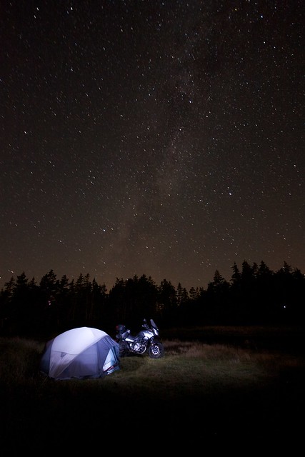
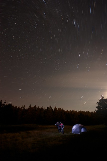
As twilight faded into darkness the already sparse traffic on the road ceased completely and the clouds receded to reveal a glorious night sky scored solely by the crashing of the surf.
Day 8: Across Cape Breton
302 miles, 6:00 moving
One of the things that has vexed me the most on this trip is deciding how much time to spend getting to know a place and sight-seeing versus covering ground and viewing the landscape from the road. On most of my previous big international trips (when traveling by train or car) I’ve really enjoyed setting up a “base” in a particular town or city for 3-5 days and doing hikes and day-trips from there. Having that home base to return to each night allows one to try several (or all) of the restaurants in town and begin to get to know some of the rhythms of that locale in ways that are impossible if you show up late and leave early. Being completely nomadic on this trip has allowed me to see a large swath of territory, but not without sacrificing that more intimate sense of place. I keep feeling torn between the two styles of travel, but so far on this trip finding out what’s over the next hill keeps winning out.
At some point in the pre-dawn twilight a muffled splash, hiss, and soft cursing pass through my consciousness and are promptly discarded as nothing to worry about. I awake at 7am and emerge from my tent rested and ready to meet the glorious morning. I wander up to the beach and say hello the source of the twilight noises: a man named Sean Foley who had nearly sunk his car in the flooded meadow while coming in to fish for striped bass from the beach. Not knowing what a striped bass was or how one would fish for it I asked for and received a good overview before wandering back to my tent to get started on breakfast. Not 5 minutes went by before Sean walks by with a fish the size of my leg (29-inches, that one) and puts it in his trunk on ice. Before I finish packing he lands a 28-inch fish to go with the first.
I’m actually on the road by 9am for once and head off toward the causeway connecting to Cape Breton. My goal is to loop around the eastern shore and see the Ile Madame before working my way to the Louisbourg historic site for the afternoon. The weather forecast seems variable though, so I decide to hold off on a firm plan until after lunch. The Ile Madame was much smaller and flatter than I was expecting, though pretty none the less. I stopped in what I’m assuming is the main village on the island, Arichat, and was initially foiled in my quest for cuisine when the only restaurant I could find had a sign on it’s door say “closed for lunch 12-1”. Really?!?!? A restaurant that closes so the proprietor can go off for lunch at lunchtime?!?!? After a few more loops around the village I found an alternate joint: Sporty’s Take-Out, a little fry shop where I filled up on fried seafood and fries with gravy while chatting with a few locals.

I checked the weather again and the forecast was now for sun all day today followed by rain for the next few days. After 5 days in Nova Scotia I still haven’t seen the dramatic cliffs into the sea that I had been imagining. Apparently almost all of Nova Scotia is [beautiful] rolling lowlands and the mountains are only to be found on the northern end of Cape Breton. Since the mountains were what I really wanted to see (and ride) I decided to skip on Louisbourg and make straight for the Cabot Trail and Meat Cove.
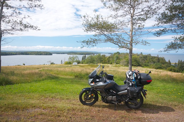
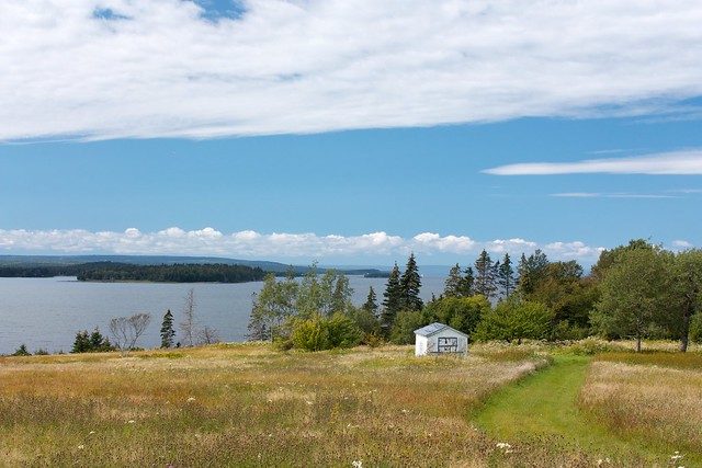
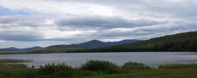
My route across Cape Breton took me along the Bras d’Or Lake, a brackish body of water similar in size to my local Lake Champlain, that almost cleaves Cape Breton in two. The rolling hills along the lake-shore were quite scenic but not jaw-dropping.
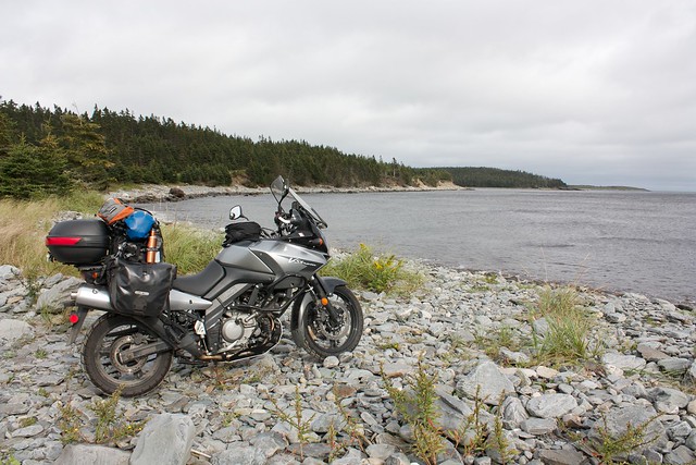
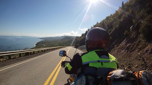
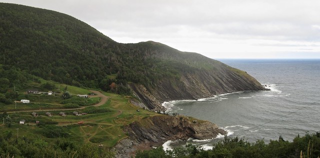
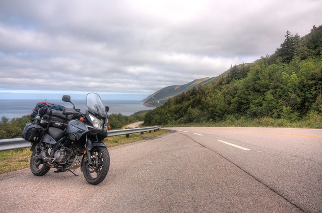
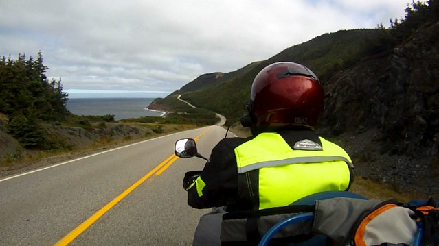
After rounding the top of the lake I finally arrived at the “World Famous Cabot Trail” and was immediately introduced to its majestic curves. I was riding the Trail counter-clockwise, starting from the southeast end and working my way north. On a whim I decided to skip the Englishtown ferry and start the Cabot Trail right from its more southerly junction with Highway 105 and was glad that I did. That first section of the the Trail was a splendid serpentine road with good pavement and absolutely no traffic. The sun was shining, the scenery beautiful, and the road magnificent. Then I came to Cape Smokey and my jaw dropped. Here was the road of my dreams, twisting and turning up the cliff-side with the sea far below. It was so good that I rode back down to do it again. And again. 😀
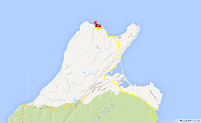
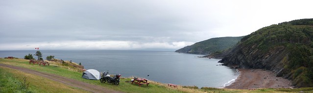
After the fun at Cape Smokey, continuing north the Cabot Trail was still a blast, but just a bit more tame. Near Dingwall I left the trail and headed north to get to Meat Cove, a tiny village of about 60 inhabitants and campground at the northern tip of Cape Breton Island. The road to Meat Cove was thrilling as well, with winding paved sections and even more twisty dirt ones. The coastline surrounding Meat Cove is stupendous, with layers of shale and other rock formations crumbling into the sea. Where most campgrounds are situated on flat areas, the Meat Cove campground is perched on a steep hillside with sheer cliffs below. A variety of flat spots are carved into the hill so that you won’t roll out of your tent, but this is definitely not a place to wander around in the dark while heavily intoxicated. I set up my tent as the evening sun slipped behind the headlands, repeatedly pausing to marvel at the view. I hadn’t fully recognized it before, but getting here was the goal of the trip — to be where the mountains meet the sea. I’d naively hoped to find this kind of scenery scattered throughout Maine and Nova Scotia only to be foiled by less dramatic elevations. Now I had arrived.
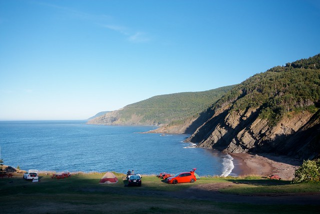
Eventually I managed to get my tent set up on a somewhat-flat spot and ate a surprisingly tasty dinner at the campground’s Chowder Hut. While I was eating another camper came in with a report of whales in the cove, but they were gone by the time I got outside. After chatting with several groups of travelers — including four 20-something guys from Maine riding three Shadows and a V-Strom who had been planning to hammock-camp and were caught off guard by the lack of trees — I hit the sack early and fell asleep to the crashing waves yet again.
Day 9: Meat Cove
Day 9 stats: no riding
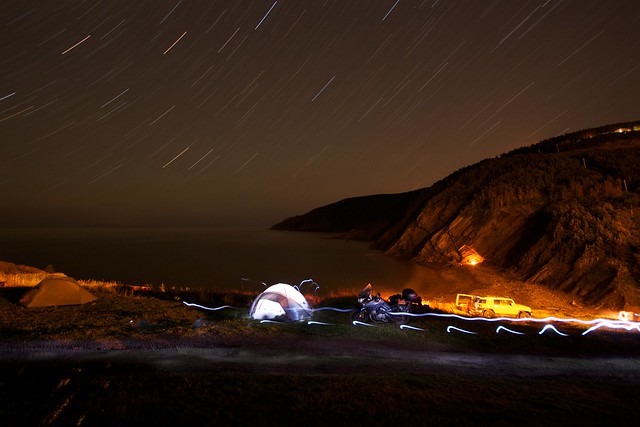
As of last night the forecast was for rain, so I wasn’t too surprised to wake up to a downpour striking the rain-fly of my tent. I checked the weather report — rain and fog all day — and went back to sleep to wait for the worst of it to pass. I was at the end of the road and there was nowhere further to go on wheels without backtracking. There is something freeing about being at the end of the road or the top of a mountain; you’ve now seen what lies over that next hill and the inability to continue forward [or upward] provides a check against continued progress only for the sake of continued progress, providing space for a pause and reflection. This part of Cape Breton was my goal and where I’d envisioned traveling to, so there was no need to rush off. I’d rather spend the day hiking at Meat Cove rather than have to creep around the most scenic part of the Cabot trail in the rain and fog. With nowhere else to be, I ate breakfast in the tent and emerged to chat with the very damp foursome from Maine — the guys whose hammocks couldn’t be used without any trees and had slept on the ground with a tarp partially covering them. Luckily the rain only caught them after dawn and they weren’t tired as well as wet. I wished them safe travels as they spun off in the muddy drizzle for their own Cabot Trail ride. After processing photos and writing for a few hours I found the campground manager, Justin, and got set up for a kayak rental. If figured the misting rain wouldn’t be much of a bother if I was getting wet from splashes anyway.
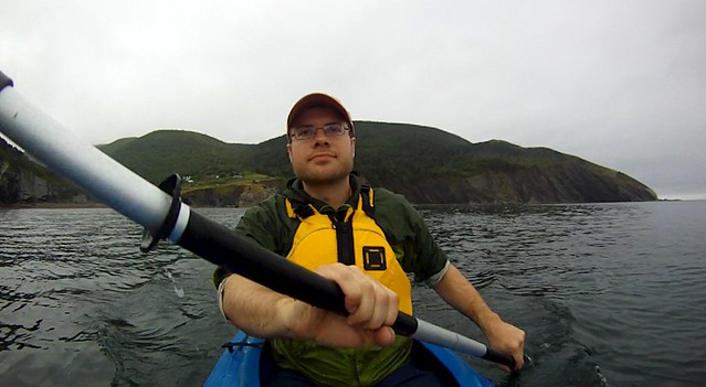
Wearing flip-flops I unsuccessfully scrambled down the steep path to the beach — managing to cover my full backside with reddish mud in the process — then forded a small stream to meet Justin where he had dropped off the kayak on the beach. The sea was quite calm as I shoved off, with no chop and just some gentle swells. About 300 meters from shore I was watching a cormorant when beside it rose a large fin that started waving back and fourth. I paddled closer to investigate. I got to within about 10 meters of the fin which appeared to be attached to a whale of some sort that was laying on it’s side just under the surface. I didn’t want to get too close as I had no idea how big it was, but it disappeared beneath the surface before I could see its full outline. It came back up a few minutes later, but then disappeared completely before I could get as close as the first encounter. Later I was told that it was likely a Minke or Pilot whale as those are the two species they’ve been seeing a lot of recently.

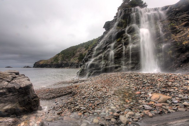
After bobbing about for quite some time hoping the whale would return I paddled east across the cove to a decent-sized waterfall that tumbled over a final escarpment and onto the beach. I hung out at the waterfall for a while taking photos and just watching the shifting patterns of light as the clouds continually broke their grasp of the sun and reclaimed it. Eventually I got back on the water and began to paddle out to be able to see around the eastern point of the cove only to find that while I was on the beach a ripping wind had picked up out of the west. Not wanting to get blown around the point I headed upwind for a few minutes with the rising chop breaking over the bow and spraying back in my face. This aspect of sea kayaking was distinctly less pleasant than my calm paddle to the waterfall so I turned toward shore to get some protection from the headlands. Eventually I got close enough to the cliffs that the chop subsided and I worked my around the shoreline to a second waterfall before peeking out around the wester point of the cove. The view to the west was of even bigger rusty-red cliffs dropping into the sea. I wasn’t able to really enjoy the view due to the high winds blasting me in the face with spray, but I imagine it would be a great sight on a calm and sunny day.
After bobbing about some just enjoying being on the water I decided I’d had enough and paddled back to the beach with no idea what time of day it was. Upon climbing back up to the campground I found I’d been on the water for 4 hours — not a bad way to spend a rainy day. A bracing shower later I no longer felt sticky from the salt spray and headed to the Chowder Hut for an early dinner. As the afternoon progressed into evening other travelers stopped by the Chowder Hut for some food and a view before heading on their way. I had a nice chat with four guys from Quebec doing the Cabot trail on adventure bikes who confirmed my fears about the weather, saying that the whole western side of the island was thick fog broken only by rain. They were followed by a couple from Toronto that had hiked the Skyline Trail (supposedly one of the best views in the park from the top of a massive cliff) only to find that they could see roughly 10 meters through the fog. My decision to stay and relax in Meat Cove looked better and better.
While I was having dinner the rain picked up again and I spent most of the evening in the Chowder Hut processing photos and chatting with new arrivals. Around 7pm I was quite surprised when I recognized the faces walking in the door: the young woman from Canso and her French boyfriend that I’d met on the County Harbour Ferry several days before! Kind of wild to encounter the same folks 350 miles and several days away.
Here are few notes about Meat Cove in case you are thinking about heading there. The campground has 35 “spots”, but only 3 or 4 have a large enough flat area to park a small camper-van on the level. Of the rest, about half can have a car or bike parked beside them and a few more can be accessed by a very careful 4WD operator. The remaining spots require leaving the car on the road above and walking down. The facilities lean to the Spartan and jerry-rigged end of things, but the price is good, the food at the Chowder Hut decent, and the view magnificent. They also have several cabins available that have a few beds and mattresses if you prefer that to a tent. One last note: the campground is first-come-first-served, so get there early if it is a beautiful holiday weekend.
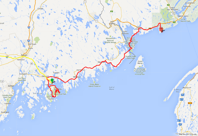
Day 10: Cabot Trail – West
279 miles, 5:55 moving
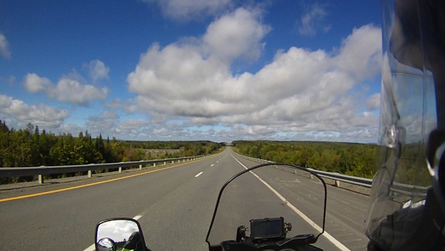
Labor Day arrived with the sun peeking from the horizon under overcast skies. It wasn’t the gorgeous bluebird day I was hoping for, but at least no rain or fog were present. I had made it to bed early last night and woke up refreshed at 7am. For the second time on this trip I was able to get rolling before 9am, though I almost dropped the bike 3 feet later while spinning on the sloping wet grass of my campsite. Luckily the tires bit in as the bike started to lean and I was propelled up the hill and out of the campground. The road from Meat Cove back to the Cabot trail was even more lovely than I remembered from the way in with the paved sections hosting numerous tight curves that I’d had a hard time appreciating while riding into the glare of the setting sun. Rejoining the Cabot Trail near Dingwall, I followed it southwest through a long valley that reaches into the heart of the highlands. Along the valley floor I spotted a bull and cow moose standing in a field, but they had disappeared by the time I circled back with my camera ready. Toward the southwest end of the valley the Cabot Trail begins climbing to the flat-topped plateau of the highlands in a lovely stretch of serpentine asphalt. Approaching the top of the 1,300-foot plateau, the road climbed into the low clouds. The going was slow for several miles while the mists were thickest, but soon the road dropped out of the clouds again toward the coast at Pleasant Bay. I didn’t stop at Pleasant Bay, but the view from the Trail was mostly of signage for various tourist attractions of the sort that mainly market to the tour-bus crowd.
South of Pleasant Bay the Cabot trail climbs a lovely sequence of eight switchbacks back up to the top of the plateau. I couldn’t help myself and went back for several more passes up and down the mountain. Once it had climbed from the shore, the Cabot Trail continued south along the coast toward Chéticamp, rising and falling along the mountainside with wonderful views the entire way. This section of the trail didn’t have the exciting hairpins of the climb from Pleasant Bay, but the scenery more than made up for it.
I stopped in Chéticamp at the most promising restaurant I saw, the Restaurant Acadien. This turned out to be a funny place where the waitresses were dressed up in bonnets and period costume while a fiddler played various jigs. The menu was limited to traditional Acadian foods and I’d had my fill of fish-cakes, so I had a piece of the reasonably-tasty-though-somewhat-bland meat pie. The most interesting part of the meal was that the bread was served with butter whipped together with molasses. I’m not a huge molasses fan — far preferring maple syrup for flavored sweetness — but the butter was better than I was expecting.
Soon after Chéticamp I left the Cabot Trail for the Ceilidh Trail as the former headed inland and the later hugged the coastline. The Ceilidh Trail didn’t have the majesty of the Cabot Trail’s highland cliffs and tight switchbacks. It was a pleasant route none the less, with a few curvy sections and many lovely coastal views. I reached the Canso Causeway at 1:00pm and left Cape Breton for the mainland, riding west on the highway toward New Glasgow under darkening skies.
I was now at crossroads both physical and metaphorical; Cape Breton had fulfilled my quest and I was torn between avoiding the rain by buzzing home on the highway or continuing along a semblance of the route I’d planned and making a brief crossing of Prince Edward Island. While I was not looking forward to more rain and not feeling up to camping in it, pounding the super-slab home for two days didn’t sound particularly appealing either. Figuring that I might as well see what I’ve been missing by not leaving more time for it, I hopped on the ferry to PEI.
The ferry to PEI took longer than I had expected and I disembarked in the evening under a light drizzle. A brief look at the map indicated that the closest significant village was Murray River, about 15 minutes away. Hoping that this village would contain accommodation, a quick Google search for “Murray River Bed and Breakfast” led me to the immaculate Country Charm Bed & Breakfast run by the very friendly and laid-back Joan and Glenn Saunders. After dropping my bags in my room I headed out in search of dinner. Due to the holiday most restaurants were closed, but I managed to find a passable dinner in a newly-opened establishment in Murray River. I’ve been trying to eat as much of the local seafood as possible on this trip and was a bit disappointed that the bowl of PEI mussels I ordered tasted almost exactly like a bowl of mussels anywhere else. I guess seafood that’s transported alive really doesn’t change much when shipped. Nourishment satisfied, I returned to the B&B for my first hot shower in 4 days and an extremely comfortable bed.
Day 11: PEI to Fredericton
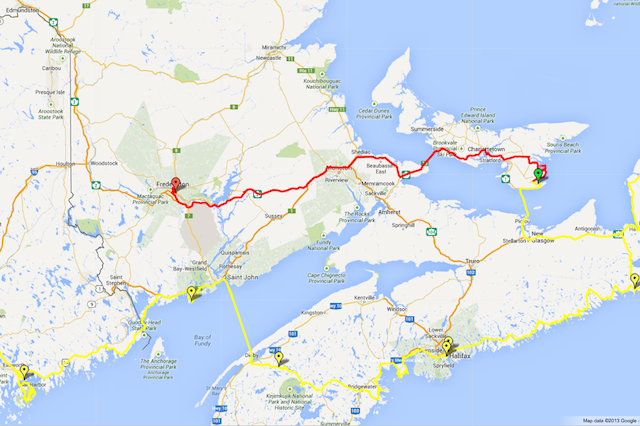
281 miles, 5:00 moving
Since I was so cozy in the the B&B and had power as well as internet I stayed up way too late writing and processing photos. Keeping up to date with the ride-report is surprisingly tough on the road if one is as particular as I am about geotagging, keyword-ing, ranking, and editing every photo. On top of that there are the HDR merges and multi-shot panorama stitching that take quite a while to process. Writing takes about an hour per evening and is easy on the battery, but photos are another story. On days when I’ve been shooting heavily and need to import and sort through hundreds of photos the laptop will use up its battery in about an hour, making photo-processing in the tent a nonstarter. Most of the trip I’ve tried to fit in a bit of photo processing during lunch or dinner, but pretty soon the backlog would pile up and I’d have to wait until I could get a long evening in a motel to finish up processing. Anyway, having stayed up too late I slept in a bit and made it downstairs for breakfast at 9am. In addition to myself there were two guests from Toronto at the family-style breakfast. Joan and Glenn made a fabulous meal of scones and fruit-filled crêpes. It turns out that Glenn is avid photographer and we had a long conversation about all things photography. It was raining most of the morning and I wouldn’t be seeing too much of PEI anyway, so I thought I might as well enjoy myself relaxing through an extended breakfast.
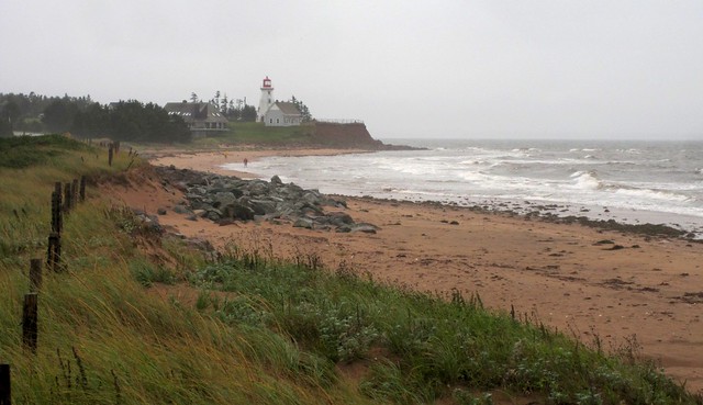
Around 11am the rain paused and I packed the bike and headed up the coast with the intension of seeing a few sights in eastern PEI before heading to Charlottetown. My first stop was Panmure Island, the site of a beautiful sandy beach and attendant lighthouse. As I turned onto the peninsula connecting the “island” to the rest of PEI I was confronted by a driving wind. I stopped for a couple quick photos of the beach and then hopped back on the bike as the rain started up again, in ernest this time.
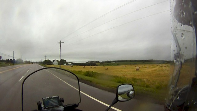
I stopped in Montague for gas and the checked the weather — rain all day in PEI, clear in New Brunswick. I decided that with horizontal rain there wasn’t much point trying to sight-see so I bailed on the distillery tour and additional lighthouses and headed straight for Charlottetown. I’ve been told that PEI has a lovely bucolic charm. The gently undulating landscape of farms certainly seemed like it could fit that description, but I had a hard time appreciating it while leaning south into the winds and rain that were gusting over 30mph.
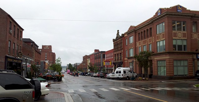
I rolled into Charlottetown at about 12:30 and found that open parking spaces on the main downtown street, Queen Street, were just about impossible to find as numerous cars circled the block looking for openings. I decided to risk a ticket and tucked the bike between two spaces behind a little tree before dripping my way into Sims Corner Oyster Bar for lunch.
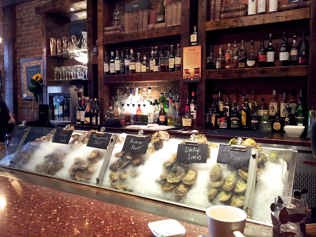
I ordered one of each of the available oysters for lunch and honestly couldn’t tell the difference between any of them except the Colville Bay oyster. That one was much more sweet and meaty-tasting than the others and was my favorite. The oysters weren’t cheap and I wasn’t up for paying what it would take to fill up on them, so followed the raw starter with a lobster roll and salad. What is it with the bacon-bits on Caesar salads? All through maritime Canada I’ve found my Caesar salads to be heaped with bacon instead of garnished with anchovies. I’m a big bacon fan, but I’ve never seen such an addition to the Caesar. Is this a Canada-wide thing?
After lunch hopped back on the bike and made my way across southern PEI to the 13km Confederation Bridge to New Brunswick. Almost as soon as I hit the mainland the rain stopped and the skies cleared. I pulled over and wrung a cup of water out of my left (upwind) boot and open up all of my vents to air-dry at 75mph. The ride across New Brunswick was a gently undulating sea of trees, scenic here and there but mostly pretty boring.
It was a beautiful evening and I was itching to camp for the night now that I had dried off, but a line of thunder storms was forecast to cross the region at 1am and I wasn’t too keen being in my tent for their arrival. A quick Google search found a cheap motel that reviews called “clean if well-worn” that would do the trick at a good price. Before pulling into my motel for the night I did a lap around downtown Fredericton and found the capital of New Brunswick to be a surprisingly pretty and vibrant town, hugging the banks of the broad Saint John River.
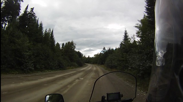
Day 12: Northern Maine
350 miles, 6:32 movingI rolled out of Fredericton at about 9:30 and hit the super-slab for two hours, the highway flanked by an undulating sea of trees. Crossing the border into Maine the flat horizon became broken by the massive peak of Mount Katahdan standing alone far in the distance. Soon I reached Millinocket and headed north toward Baxter State Park to get a closer look at this mountain which marks the end of the Appalachian trail. Having never seen northern Maine I didn’t really know what to expect except that the only roads in the area were logging roads on which the logging trucks have right-of-way. That seemed reasonable enough, so I set my GPS to allow dirt roads, then threw in a few via-points to take me from Millinocket up to Baxter, then across something called the Golden Road for 23 miles before turning off on a smaller logging road for another 15 miles to Frenchtown where I’d pick up the pavement again on the way to Moosehead Lake and Greenville.
My dad had been telling me about a particular spot with good views of Katahdan that he used to visit a lot when he lived in Maine, so upon entering Baxter State Park I walked into the visitor center to figure out how to get to there. While looking at the big park map I asked the slightly-grumpy ranger about how long it would take to get to Sandy Stream Pond, to which I got the abrupt reply, “You can’t ride there.” I was a bit confused and asked if what looked like a road on the map was actually a trail. “No bikes are allowed in the park”, he said, “The guy who gave the state the land for the park had rules: No pets, no motorcycles, no running water. Even though he’s dead he still pays my salary so I enforce them.” All right then. I guess I’m not getting closer to the mountain and will be on my way. “Which way are you headed?”, he asked. I said I was going to take the Golden Road for a while and then turn down to Greenville. He asked what I knew about the Golden Road. I answered truthfully that I didn’t know much other than it was gravel and to give the loggers right-of-way. He gave me a stern look, saying “You better have good tires because it’s a private road and there is no cell service, no help, and no one is going to care about you. You should just turn around and head back to I-95.” Seeing as this information source was likely a dead-end I turned around and headed out of the park before swinging onto a small connector to the Golden Road, figuring I’d at least take a look at it first before making a decision as to which way to go.
At the junction with the Golden Road I stopped for a bio-break and looked at the road. At this point it was partially ground-down asphalt, nothing particularly bad. Given the many miles of gravel roads and jeep trails I ride in Vermont I wasn’t hesitant about a bit of gravel, plus I did have some good 80/20 tires on the bike that hadn’t seen enough dirt yet. While I was contemplating the road an empty logger passed, followed by a little RAV4 mini-SUV towing a wooden sailboat. The off-road “capabilities” of the RAV4 and boat combination sealed the decision and I followed the RAV4 at an easy pace, watching his movement for signs of approaching log-haulers. For my 20 miles on it, the Golden Road wound along some pretty rivers and lakes with a surface that was mostly ground-down pavement and several stretches of gravel.
Three times the RAV4 dodged to the side and I eased off the road to allow big rigs to pass by at full speed. Unfortunately I never had my camera running, but the loaded trucks were quite a dusty sight barreling along at 50mph on the gravel.
Near Caribou Lake my route took me off the Golden road and onto a smaller road that didn’t seem to have any current logging activity. The surface was firmly packed gravel that hadn’t been graded in some time, leaving some stretches washboard and others beautifully smooth hard-pack. The scenery on this road was mostly the road and trees with only fleeting glimpses of lakes and distant mountains.
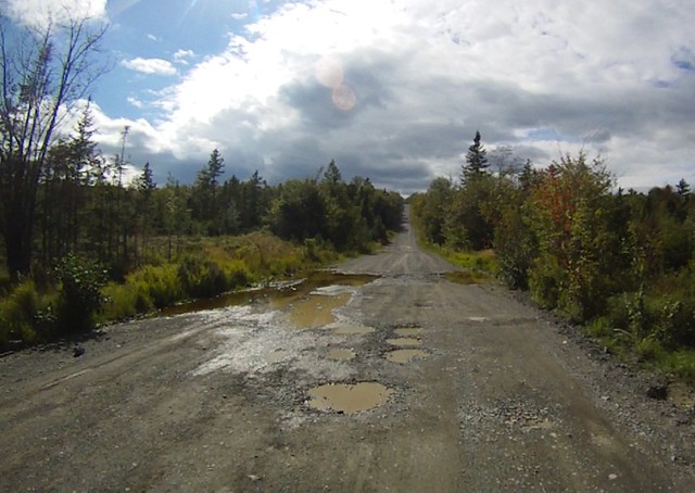
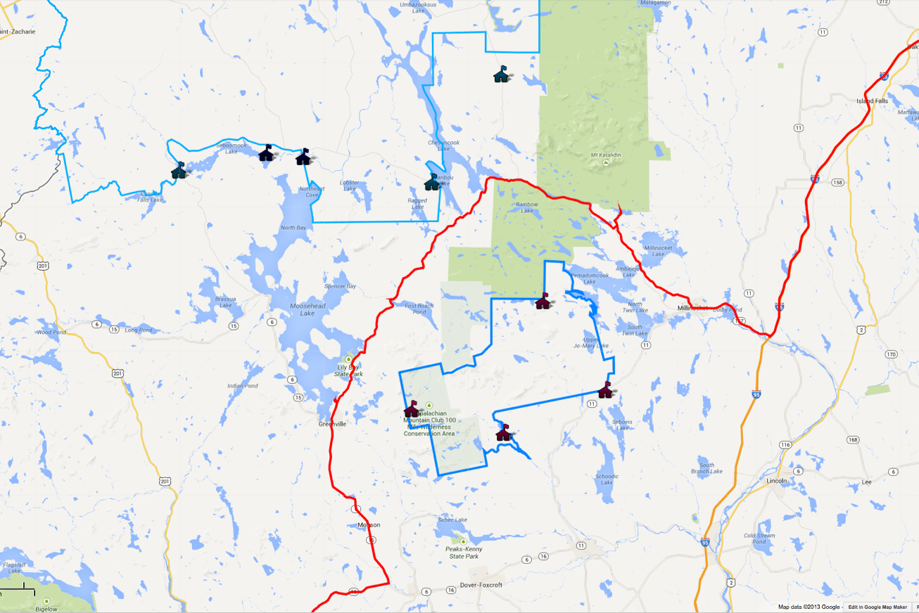
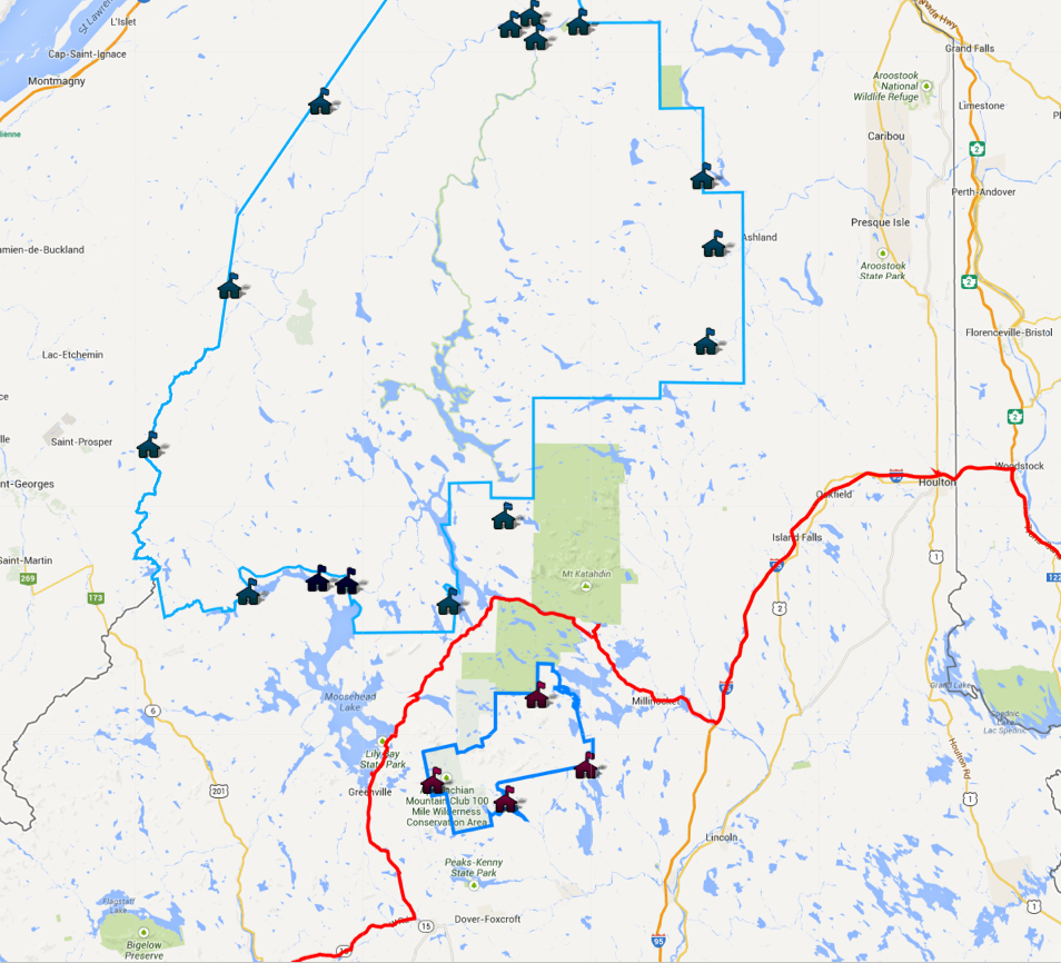
At Frenchtown I joined the pavement again after riding 35 miles of logging roads without incident. Later when I got to an internet connection I did some more research into the Golden road and after several hours of searching and reading am still not sure if the section I rode is really open to motorcycles or not. What is clear is that no motorcycles are allowed in Baxter State Park, the North Maine Woods, or the KI Jo-Mary area. From all of the maps and GIS data I’ve found, it seems that the Baxter State Park boundary stays on the northern side of the Penobscot River, while the Golden Road is to the south of the river. The large area south of the Golden Road is owned by The Nature Conservancy which doesn’t list motorcycles as prohibited, but that point is likely moot as it doesn’t look like the Golden road actually enters their Debsconeag Lakes Wilderness Area. North and west of where I turned off the Golden Road is the North Maine Woods, an area with entry check-points that specifically prohibits motorcycles (shown in blue-outline with markers on the check-points):
Long story short, I didn’t see any obvious signage on the section of the Golden Road I was on that prohibited motorcycles, though there were signs warning that motorcycles were prohibited in Baxter State Park. No one hassled me and I didn’t pass any checkpoints. That said, the status of motorcycle usage of this section of road is still unclear to me, so I can’t fully recommend it. If it isn’t open to bikes, then as far as I can tell the most northern route a motorcycle can take across central Maine is ME-16 near Dover-Foxcroft and ME-11 to Millinocket. It’s quite a bummer that such a huge area is closed to motorcycles, but that seems to be the state of things.
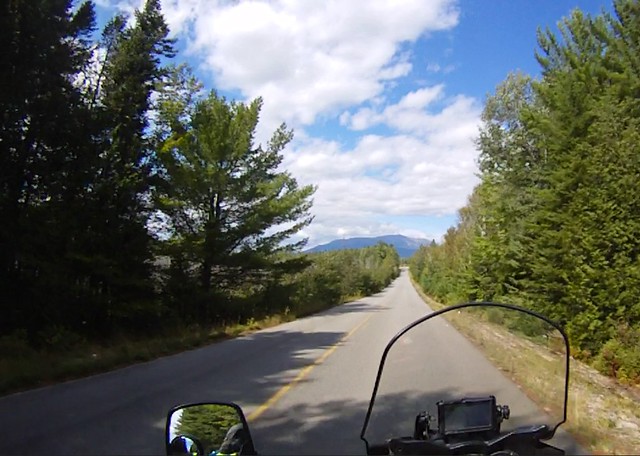
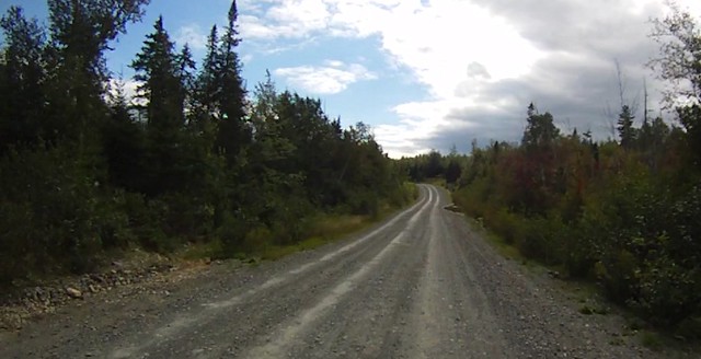
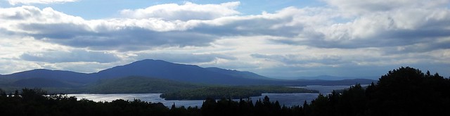
Once I hit pavement again I wound south along the beautiful Moosehead Lake and past Greenville before turning west again on ME-234, ME-4, and ME-16 to Rangeley. These roads were quite scenic with many vistas of forests, lakes, and distant mountains. A few sections were fun and twisty, but nothing worth going back to ride again and again. Even though I was well out of the reserved wilderness areas, there didn’t seem to be too many people living in north-western Maine outside of the Kennebec and Strong river-valleys. There were a few villages here and there, but not many and not large. When I entered the 1,200-person town of Rangeley as the sun was going down, it was the most significant village I’d seen for quite some time.
I followed ME-16 through Rangeley until the lake-side cottages petered out and more logging activity lined the road. Every half mile or so there was a gravel turn-off where in years past loggers had loaded their trucks when cutting on the hillsides above. These were now disused and slowly returning to forest with grass pushing up through the gravel. I picked one that had a nice bend out of sight from the highway and after verifying that it was free of “No Trespassing” signs, set up my tent for the night.
My stove likely needed some cleaning and was acting up, but I hadn’t disassembled it before and didn’t want to get into that in the dark while exhausted and with rain clouds threatening. I nursed the flame enough to get my water close to a boil and sat down to a dinner of Mountain House beef stew. I hit the sack right after dinner at about 8pm and was asleep in moments.
At 3am I woke up a bit chilly. My normal bedding stack — Thermarest mattress topped with a flannel sheet followed by me with my down mummy bag thrown over like a blanket — wasn’t quite enough. The temperature had dropped in the night and I climbed into the sleeping bag and zipped it up tight. I’d already gotten seven hours of sleep, so I lay awake for a few minutes waiting for sleep to come. Just as I was about to dose off again I was startled awake by the crack of large branches snapping in two and heavy, plodding footsteps headed my way. Bear or moose, which was it? I didn’t have any food in my tent, but I’d just packed my food and trash on the bike 3 feet from the tent — not particularly good bear-country practice. With my bright flashlight and swinging my tripod as a club I figured I could scare off a 300-pound black bear at least once if needed, though likely not successfully from within my mummy bag. Moose were a different story though. At close to a ton and with antlers to boot, an angry moose is a dangerous foe that I did not want to be playing tag with in the dark. Since I had a little mobile service from my campsite I quickly Googled “moose attack tent” in case that was what was out there. The results were encouraging: “Moose and elk know that you are there by smell, but seem to consider tents and vehicles inanimate parts of the landscape and nothing to fear.” One poster in a camping forum related that a moose walked through his laundry lines and left with his socks stuck in it’s antlers, but didn’t bother the tent. I waited and listened for sounds that would differentiate the beast outside the tent. After a minute or two that dragged on seemingly much longer I hear a snapping of saplings, a crunching of woody plants, and phhffbbbbbffhhbbb sound like a horse makes blowing air out it’s lips. A moose not a bear! It let out a big horse-like fart in confirmation. Now I just need to stay quiet and not startle it. I had a strong desire to see the animal, but an even stronger desire not to be gored, so I kept the flashlight off and hunkered down in my sleeping bag. After a few minutes the crunching and heavy steps dissipated and I fell back asleep.
Day 13: Return to the Green Mountains
Day 13 stats: 246 miles, 5:13 moving
With the early bedtime I woke up well-rested at about 7am and went out to look for tracks left by last night’s visitor. The hard-packed gravel near the tent didn’t allow any impressions so I followed the bent grass to where the moose had emerged from the woods. There I found a line of 8-inch cloven-hoofed prints as well as the 6-inch diameter log whose cracking had startled me last night. I’d finished my oatmeal packets and was in the mood for eggs anyway, so I backtracked a few miles to Rangeley and stopped at Moosely Bagels for a sausage, egg, and cheese sandwich and several mugs of coffee.
After breakfast I continued west on ME-16 as it wandered along the lovely Androscoggin River near Umbagog Lake in a long chain of sweeping turns.
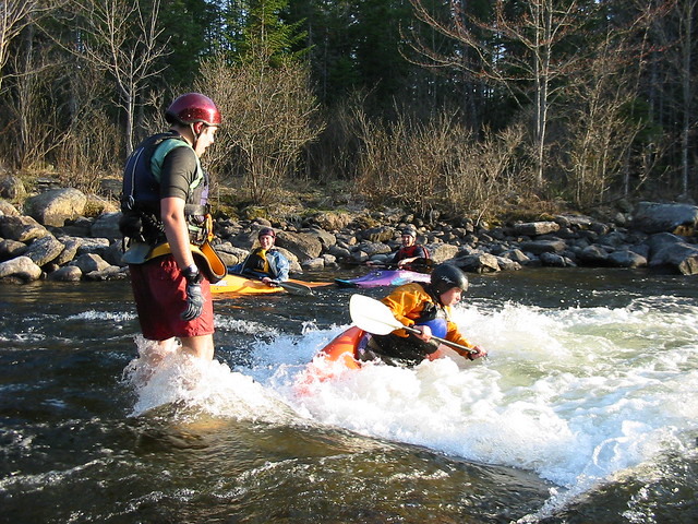
My last visit to this area was about a decade ago when I attempted a springtime whitewater kayaking run of the Rapid River with a group of friends. Unfortunately it was still mud-season when we arrived and the logging roads back to the river were closed and gated. Given the inability to travel on terra-firma we proceeded to paddle our stubby little whitewater boats 11 daunting miles into the wind across Umbagog Lake, only to find that the Rapid River wasn’t flowing due to stockpiling behind the dam. The trip as a whole ended up being quite an adventure and a lot of fun even though this was the only smidgin of whitewater we saw:
In Errol, New Hampshire NH-16 bore south and I turned west again on NH-26 toward the Dixville Notch. Dixville Notch is both a mountain gap as well as a small community of 12 inhabitants that is usually the first to certify their presidential votes each election, when 100% of the votes are counted within several minutes of midnight on election day. The road through the notch wasn’t particularly long or twisty, but it was quite scenic with granite spires guarding the pass and the pretty “Balsams Grand Resort Hotel” holding court over a small lake just west of the pass.


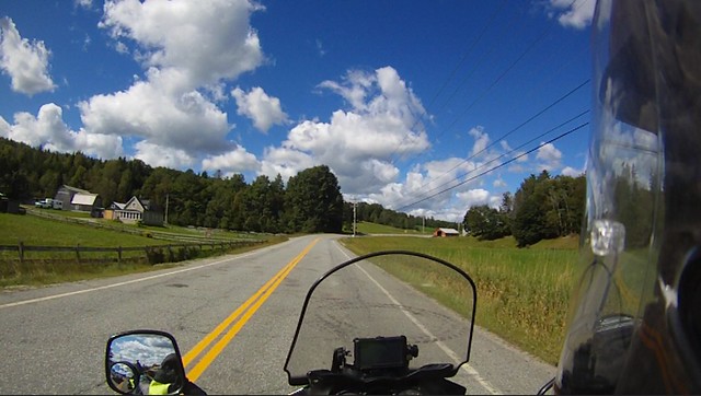
Like northern Maine and New Brunswick, northern New Hampshire is full of mountains, lakes, and a sea of trees broken only by the former and the few roads that cross the region. There are farms here and there in the river valleys, but for the most part the villages seem small and remote. After two solid days of riding across this forest I was struck by the change in landscape that occurred almost as soon as I crossed the Connecticut River into Vermont. Vermont’s “Northeast Kingdom” is the most isolated part of the state, but in comparison to the stark wilderness I’d been riding through it was a veritable Eden. Vermont is 75% forested and certainly doesn’t lack for trees, but here the forests dominate the tall hills and mountains while giving way to a patchwork of farms large and small in the lowlands. While it is still remote and sparsely populated by western Vermont (let alone metropolitan) standards, the tilled landscape supported villages and economic activity at a level I hadn’t seen since Fredericton.

Over the course of the long morning I wound my way across the Northeast Kingdom through the towns of Island Pond, Orleans, Lowell, and Eden before crossing the northern spine of the Green Mountains on VT-109 to Jeffersonville. As I cruised through the rolling countryside I thought a lot about this trip and its imminent end. On the practical side, I was feeling great after 13 days on the road and would be happy to just continue at this pace indefinitely. While this trip hasn’t had a lot of downtime and there were no long days lounging on the beach, I did quickly loose track of the day of the week and feel quite mentally restored. I’m quite pleased at how well it worked out given my choice to do this trip solo. While the camaraderie of tackling an adventure with others and conversations around the campfire would have been a nice, I was surprised that when I was most alone — on a wilderness road or camped far from others — I never felt the hunger for human contact. I’d like to join with others for future big adventures both for the camaraderie as well as to have help close by, but I no longer have the same trepidation about traveling solo. Another big question I had going into this trip was whether or not camping would be a comfortable long-term option. While thunder storms and multiple days of heavy rain may still chase me into motels, I really enjoyed the camping — especially in the out-of-the-way spots. The new air mattress has soothed my horrible memories of waking up knotted and sore on a foam “RidgeRest” and I look forward to much more tenting on future trips.
Even now I’m not sure that I have an answer for the bigger question of what I was hoping to gain from this trip. Whether they were what I was looking for or not, I did get a chance to see a few things: what’s over the next hill, and the next, all the way to the end of the road; the mountains meeting the sea; some of the largest beasts on the continent and off its shores. I also got a chance to verify that yes, I can be continue to be at peace with myself while alone and away from people and places familiar. I’m not ready to set off on a multi-year round-the-world trip yet, but a month or two on the road now seems within the realm of possibility. I can find a bit of adventure and come out the other side.

Arriving in Jeffersonville, I enjoyed a late lunch at the 158 Main Restaurant happy to be out of the woods and back in the world of solid restaurants serving a wide variety of locally grown meats and veggies. I’d told my friend that was house-sitting that I wouldn’t be home until mid-afternoon, so I took my time and wound my way south through Underhill, Jericho, and Huntington on various back roads. Truthfully, I didn’t want the trip to end and extending it by taking the scenic route seemed like a nice compromise between the part of me that was ready to get back to normal life and the part that wanted to turn west and continue across the country. Along the way I got a text-message that my house-sitter was still cleaning, so I detoured back up into the mountains and explored a couple of miles Class-4 roads (TH-25/Green Rd) near Lincoln to delay my arrival and to test out my gear on more challenging terrain. These were by far the roughest “roads” I traveled on this trip and the bike handled the washouts, water bars, and mud surprisingly well for being so heavily loaded. The extra weight did lower the clearance a bit and the skid plate got a solid workout as I scraped over many spots. After a couple of miles on the jeep trail I was back to smooth gravel and turned down the mountain toward home.
Summary Statistics:
- 2629 miles on the odometer, roughly 100 miles of which were dirt/gravel roads
- 5 ferries
- 13 days and 12 nights traveling
- 5 nights under roofs and 7 nights camping
- 1 night in a dojo, 1 night in a hostel, 1 night in a B&B, and 2 nights in motels
- 3 nights camping in public campgrounds, 4 nights camping in out-of-the-way spots
- 3 states in the U.S. and 3 provinces in Canada
- Usual daily riding time: 5.5-6 hours


What a great voyage, wonderful written descriptions,and splendid nature and weather, Adam!
love, Dave
This is a fantastic travel story, Adam! reminds me a bit of “zen and the art of motorcycle maintenance”. I’m really excited about the new V Strom that dad and i got, and looking forward to planning another trip like this with you! Would you consider going back to Nova Scotia?
Wow … what a fantastic journey and love your VStrom! Always enjoys traveling to the east coast of Canada, so different from the west coast where I live! Thanks for sharing the story and great pics!
Good day sir,
Just came across your trip.
I live and work in bear river n.s. Was very sad to learn you did not like our village on stilts. The little Switzerland of America.
Did you stop and visit the visitors center lots to do here.
I would ask you come back and visit us again to really see and feel it,
Thank You
Louise Wood