A new version (1.2.2) is available that fixes issues with image URLs
This version is a re-release of version 1.2 which had a corrupted archive missing some necessary files.
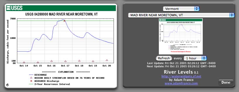
The RiverLevels widget provides an easy way to monitor the amount of water flowing in your favorite streams and rivers right from your Dashboard. The RiverLevels widget is of particular interest to whitewater kayakers and canoeists.
Once any United States Geological Survey (USGS) stream-gauge station is selected, it is automatically refreshed to always provide you with the latest graph of the water-level. As of version 1.2 you can choose between two graph styles: discharge in cubic feet per second (CFS) and water-height in feet.
This widget is Free software, licensed under the GNU General Public License (GPL) version 3 or later.
Requirements:
- OS X – 10.4 “Tiger” or later
Change Log:
1.2.1 (2008-02-10)
- New zip archive includes the ‘library’ directory missing in the 1.2 release.
1.2 (2008-02-06)
- Fixed Leopard (10.5) compatability bug.
- Added the ability to choose Gauge Height (ft) in addition to discharge (CFS).
1.1 (2007-01-08)
- Fixed graphs extending off bottom of widget
- Fixed invisibility of front refresh icon


Adam,
I use and enjoy your river levels widget. After update to Leopard this weekend, however, it no longer works. Will you be updating?
Thanks,
Tim
Yes Tim, I’ll update the widget as soon as I get Leopard installed. It will probably be a few weeks, but I’ll send you an email when it is done and make a blog post.
– Adam
Riverwidget does not work with OSX 10.5.1. Getting a “Error refreshing graph, cached data is displayed”
Any ideas?
This fixed my 10.5.1 issue that I logged on the 1.2 page, obviously a package problem. Thanks for the quick update.
Hi Adam,
Thanks for the River Levels widget. Being both a mac addict and the son of a fly fishing shop proprietor (http://forwardcast.net), I quickly saw how useful this could be for the shop. However, I thought that your widget could be extended to mobile devices too (e.g. iPhone). Therefore, I’m currently working on Ruby on Rails implementation of your widget only less graphical and more text based. Although, now that the iPhone SDK is available, your widget might make a good iPhone/iPod Touch application too.
Chase
Adam,
Great widget. Is there any way to add USGS stations? I’d like to have the South Platte above Lake George (PLAGECO).
Pingback: Measure River Levels on Your Desktop « UnEarthedTees’ Geology News
Todd, the station list is built dynamically from the USGS site with a URL similar to the following (with ‘ny’ being the abbreviation for New York:
http://waterdata.usgs.gov/ny/nwis/current?index_pmcode_STATION_NM=1&index_pmcode_DATETIME=2&index_pmcode_00065=3&index_pmcode_00060=4&column_name=station_nm&column_name=site_no&sort_key=station_nm&sort_key_2=station_nm&format=sitefile_output&sitefile_output_format=xml&rdb_compression=file&list_of_search_criteria=realtime_parameter_selection
The same page in HTML format instead of XML:
http://waterdata.usgs.gov/ny/nwis/current?index_pmcode_STATION_NM=1&index_pmcode_DATETIME=2&index_pmcode_00065=3&index_pmcode_00060=4&column_name=station_nm&column_name=site_no&sort_key=station_nm&sort_key_2=station_nm&rdb_compression=file&list_of_search_criteria=realtime_parameter_selection
These are urls are built from the real-time water data search form. If the station doesn’t show up there, then it won’t appear in the list.
The graphs displayed in the widget are pulled directly from the USGS site and not generated in the widget. Therefore, the station page will need to have graphs on it for which I can get the URL. If you give me a url to the station page I might be able to figure out why it isn’t showing up in the list and if it will be possible to add support for it and similar stations.
Adam;
Use and love the the River Level Widget. Wondered if you ever considered converting it into an iPhone/iPod App? Did a little bit of research and found that there is a bit of cut-and-paste “example code” that launches a UIWebView object, which will then allow you to run a JavaScript inside. Could potentially be a fairly simple port, with a lot of re-use of the River Level Widget’s Java.
Ref:
http://forums.macrumors.com/showthread.php?t=774270
http://developer.apple.com/iphone/library/documentation/UIKit/Reference/UIWebView_Class/Reference/Reference.html
Keep up the good work!
I used an older yellow river levels dashboard widget on my mac that is no longer with me. Yours is nice, but my issue is I need to look at a couple of different river levels, and w/out loading up a bunch of widgets. Any ideas?
Love the river levels widget – what I have been exhaustingly searching for is the widget that can be uploaded and added to a website, so that the live data feed of the stream levels is always posted on the given page of that website for visitors. Any knowledge of this or plans to make your widget embeddable? Would be tremendous – thanks
-P
Hi Adam.
Thank you for making the very useful river levels widget. As an avid whitewater kayaker this is very helpful in determining the optimum time to go kayaking.
Since certain waves, hydraulics and other river features get good at certain optimum levels I was thinking it would be cool to make a graphic background that is color-coded for each river indicating when certain play spots are “in” and at good levels. I can create the graphic. Would it be possible to integrate that in to my own widget (or for other kayakers to have as well) or is that too difficult or not possible?
Imagine an iPhone app that calls you when a certain wave is really good? Crazy huh?
Just curious.
Thanks.
Chad
any chance the river widget will be available for microsoft windows 7 users..??
thanks,it is soooo cool to see on my friends apple computer.
kate
Pingback: AdamFranco.com » Blog Archive » River Levels Widget v.1.2.2 available