
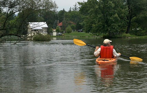
Sarah, my dad, and I took a canoe and kayak trip down the Big Spring Creek in Newville, Pennsylvania. The creek is beautiful, with clear water, many aquatic plants, and much waterfowl.
Since the creek has a tiny drainage and is primarily spring fed, it does not flood regularly (if at all) and is hence heavily silted. For about the first 3rd of our trip, the canoe was constantly scraping the bottom and getting stuck. My dad in the sea-kayak had a little bit shallower draw and only got stuck once.
After the first 3rd of the trip the channel deeped, but was still quite narrow, requiring a lot of maneuvering of the large canoe.
In a few spots fallen trees block the channel, though we were able to gingerly maneuver over or under them.
Be aware that a State Boat Registration sticker is required on all boats.
The Google Earth/Maps images are making use of two scripts that I have just written that generate a KML file from the Flickr photo set and then join the photo collection with the GPS track of our route.


Gingerly maneuver? How about: Sarah fell into the creek, clung to a tree, and is now covered in HUGE poison ivy blisters?
Hi.
I found your widget for finding river levels for my Mac. I do a bit of kayaking on the Great Miami River around Hamilton, Ohio and wanted to find out how best to use this data. What is considered a safe range in cf/s to kayak/boat? I assume time of the year is important also with cold weather, etc.
thanks for any information on using this helpful widget.
Rick
Rick,
The level of water that is safe to paddle varies from river to river, section to section, and even year to year as floods change the course of the stream and create or remove obstacles. For example, my favorite local creek (the New Haven River) is only good to run between 300cfs and 1400cfs. Any less and you can’t squeeze through the rocks, any more and some of the holes become big and scary. Another creek down the road is good from 500cfs to 3000cfs and the St. Lawrence river never drops below several hundred thousand cfs. Basically, its all relative to the particular part of the river and one’s skill level. The Princeton Outdoor Action club has a good page on river safety and planning that talks about river levels and ratings.
The American Whitewater Association provides the same information on levels as my widget (all sourced from the USGS), but with added commentary by paddler’s. Their Ohio page for instance, lists two sections of the Great Miami and has some recommendations on minimum and maximum suggested water-levels. In general, if you aren’t sure about the river level, ask local paddlers or at a local paddle shop. Once you have an idea of what to expect of the river at each level, you can use my widget to help you monitor the river and see when its in your preferred range of levels.
Have a fun and safe time on the river.
– Adam